
Discovering Saltburn's rich heritage - the Halfpenny Bridge.
Despite the opening of the Zetland Hotel in 1863 and the development of the vast ornamental gardens laid out in the glen, Saltburn was considered by many critics to be some way from being an "ideal watering place" due to a lack of amenities. By 1870, however, Saltburn was beginning to flourish as a fashionable seaside resort rivalling other fashionable watering places like Harrogate and Bath.
1867 saw the opening of the Alexandra Hotel whose owner, John Anderson, was the prime mover in the building of the pier and the hoist. 1867 also saw the arrival of the Albert Temple in the Pleasure Grounds. By 1869 another of Saltburn's famous and iconic landmarks was under construction.
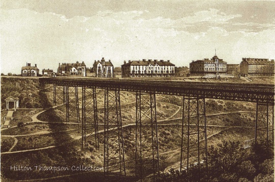
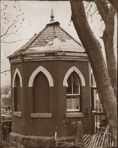
The 'Halfpenny' bridge was a typical example of Victorian enterprise and was completed in 1869 at a cost of £7000 and the lives of three workmen. It’s span, on top of seven cast iron supports, offered spectacular views of the coast and surrounding countryside. The bridge, when it opened, became known as the ‘Halfpenny Bridge’ derived from the fact that pedestrians paid a halfpenny toll to cross. The toll was taken at a toll-booth at one end of the bridge. The toll-house, which was built for the use of the toll-collector at the other end of the bridge, still survives today as a private dwelling.
The Bridge Across the Glen
Designed to link Saltburn with the neighbouring town of Skelton, the construction of the spectacular 'Halfpenny Bridge' which spanned the valley, crossing Skelton Beck, was under construction by September 1869. This impressive structure, rising 120ft above the Pleasure Grounds at its highest point, would eventually enable travellers to avoid the vertiginous road descent from the town down to sea level, and the equally arduous ascent up the other side of the glen.
The land on the east side of the Glen was owned by the Wharton family of Skelton Castle. Mr J T Wharton apparently wished to encourage the development of land on the east side where there had previously been a small community called Bank Top and the building of the bridge was a prelude to developing this area by making portions of land available for leasehold tenure.
On the 4th September 1868, the Middlesbrough News and Cleveland Advertiser reported:
"On Monday the foundation stone of the bridge, which is being built across the glen by Mr J T Wharton esq. of Skelton Castle, was laid by Mr Wilman, the engineer in charge. The spot selected for the site is a little south of Balmoral Terrace,close beside the entrance to the path leading down to the wood. The bridge will be a handsome structure, mainly of iron, and is being erected by Messers Hopkins, Gilkes and Company Limited. The cost will be £7,500 and it is expected that the bridge will be ready for traffic next year. It is understood that Mr Wharton's object in the construction of the bridge is the bringing into use a large tract of building land on the east side of the glen; and, therefore, a considerable increase in the rising little town may soon be looked for ... "
The notion that the reason for building the bridge was to enable the development of the east side of the glen is further re-inforced by a report in the Middlesbrough Exchange on 1st April 1870:
"Until recently only land on the west side of the glen, which is freehold tenure, has been available for buildings. Last year, however, a handsome lattice girder, high level bridge, 660 feet in length and 150 feet in height was erected by the owner of the land across the glen, and the land is now laid out on leasehold tenure on easy terms, and alreadt buildings have been erected..."
The contractors for the bridge was a local firm - Hopkins, Gilkes and Co. - who had already established a reputation for engine building and structural engineering having built the two gigantic viaducts of Belah and Deepdale for the South Durham and Lancashire Union Railway which passed over Stainmore into the Eden Valley in 1860.
The design of the Saltburn bridge bears a strong resemblance to those of the Belah and Deepdale viaducts. However, a number of modifications were made - some of which were quite drastic - and these were not improvements on the previous designs, a fact that was to contribute to the eventual demolition of the bridge. The two viaducts were designed for double-line railway use and both of them were able to cope with an increase in the size of both locomotive and rolling stock over the years, surviving until the 1960's. The Saltburn bridge, on the other hand, was designed solely to carry horses, carts and pedestrians and was never really safe for use by motorised vehicles. It is said that early motor vehicles did use it but Mr Wharton closed the bridge to motor vehicles after a huntsman was almost thrown over the rails when his horse shied from a car.
Building the Bridge
The projected cost of the bridge was £7,000 and the site chosen was Scott's View (as marked on Dickenson's plan) opposite the villa now named Bridge End. A parcel of land across the glen was taken on a 999 year lease by Mr Wharton from Henry Pease, Thomas MacNay and William Thompson in July 1868. The land was surveyed that same month and work commenced immediately afterwards. Work was progressing so well that by January 1869 the engineer, Mr Willman, was predicting it would be finished by April. However, the work was delayed by a serious accident which occured on the 7th April 1868 during which three men were killed and the bridge was not opened until September.
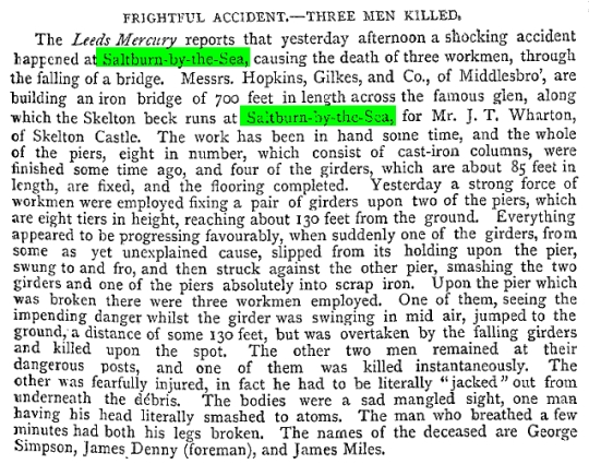
Pall Mall Gazette, April 1869.
Following the accident and inquest no further mention is given to the project in local newspapers and there does not seem to have been an official opening ceremony.
On 9th August 1869 the Saltburn Improvement Company approved the proposed tolls for the bridge which by this time was almost completed. The toll of "One Halfpenny" for each person "not being in charge of a horse or vehicle" gave the bridge the name by which it eventually became best known. The toll boards stood at both ends of the bridge until the end of its life.
Mr Wharton's visualised development of Bank Top was not a success. Apart from the toll keepers cottage the only other dwelling built on the east side of the valley was Cliffden, which later became part of the Manor School along with the White House. After the school closed in the early 1970's the building was demolished and the Cliffden Court development now occupies the site.
During it’s 105 year history the bridge gained a darker reputation as a number of people committed suicide by throwing themselves off the bridge. In the 1960’s age began to take its toll on the bridge’s supporting structures. In his report of 1971, Mr I M Little, consultant engineer, concluded that the bridge "was in the first stages of dereliction" and that its condition was hazardous to any person or vehicle supported by the bridge or passing under it. "In event of high winds failure could occur with the subsequent collapse of the bridge." A proposed refurbishment programme was found to be too costly so the decision was taken to demolish the bridge.
On December 17th 1974 at exactly 9.30am the crowds that had gathered on Saltburn's promenade witnessed the demolition of one of the town’s best known landmarks. This slender and spectacular cast iron structure, which had spanned the Valley Gardens since 1869, was reduced to a tangled heap of twisted metal in just four seconds and the vista through the valley towards Saltburn woods, would never be the same again.
The cost of the demolition was in the region of £50,000. The bridge and the Saltburn toll booth have disappeared although the toll house at the Skelton side of the bridge remains as a private residence. A bandstand has been erected on the area where the Saltburn toll house once stood along with an observation platform which has sections of the wrought iron balustrade from the old bridge surrounding it. Further sections of the balustrade were used on the new footbridge which was built to cross the beck in the valley bottom.
Research by Rebecca Hilton. Collecting primary source materials, articles and extracts from books related to the development of both Saltburns and trying to validate them has offered conflicting information, much of which is often difficult to validate as many sources can prove to be unreliable e.g. newspapers or census data. Every effort has been made to ensure that the information on the history of the town presented here is as accurate as possible.